Postglacial rebound - Sweden grows!
During the last ice age (approx. 115,000 to 10,000 years ago), the entire Scandinavian subcontinent was covered by an ice sheet approx. 2 km thick. Due to their enormous weight, these ice masses exerted great pressure on the earth's crust, which was thereby pressed into the softer earth's mantle below.
With the melting of the glaciers at the end of the last ice age, a reversal process began, the postglacial rebound. Like a cork that had been pressed under water, the land masses now float again on the viscous mantle. The process of "recoiling" was, of course, much slower than that of the metaphorical cork. Over the millennia, however, quite a bit has accumulated, and the land uplift in certain places now amounts to a good 800 meters, compared to the maximum subsidence during the glaciation.
The rate of land uplift has decreased over time, but is still about 1 cm per year in the Höga Kusten area and about 5-6 mm per year in Stockholm and Sörmland. The following figure shows the coastlines in Stockholm 7000 years before today and 3200 years before today. The increase in land mass (shown in brown) is clearly visible.
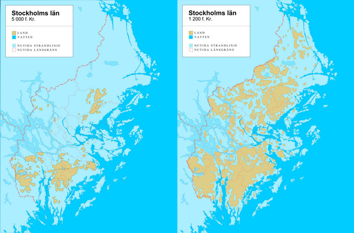
Fig.1: Land uplift in Stockholms län; left 7 000 years BP, right 3 200 years BP; land mass in brown.
Traces of the postglacial rebound
The uplift of the land masses is naturally accompanied by a sinking of the shoreline. "Fossil beaches" bear witness to the former shorelines, which today may lie several kilometers from the Baltic Sea. In Marvikarna Nature Reserve, for example, if you look closely, you can discover those former pebble beaches, which today lie in the middle of the forest and about 80 meters above sea level. You can recognize the rounded pebble stones, which could be formed in this way only by the influence of water. The lookout tower, today at a good 90 meters above sea level, stands on a former archipelago island.
The peninsula Femöre, located south of Nyköping, is depicted on a map from 1454 in the form of only five rocks in the sea. Fem means five in Swedish and ör is an old word for stone or gravel. So, this popular and well-known touristic destination has only surfaced from the Baltic Sea during the last 500 years - literally.
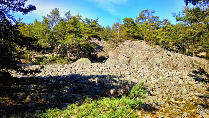
Fig.2: "Fossil beach", former coastline on today's Femöre Peninsula (2021).
What happens next?
Due to the global sea level rise, it is likely that the effects of land uplift will soon no longer be noticeable, or possibly even a rise in sea level will be observed nevertheless. Of course, this depends entirely on the global developments. In any case, the direct effects of global sea level rise will in Scandinavia be initially compensated by land uplift and thus at least slowed down.
Post sources:
- Landhöjningen i Stockholm - Wikipedia: https://sv.wikipedia.org/wiki/Landh%C3%B6jningen_i_Stockholm
- Postglaziale Landhebung - Wikipedia: https://de.wikipedia.org/wiki/Postglaziale_Landhebung
- wiefunktioniert.com: https://www.wie-funktioniert.com/nacheiszeitliche-landhebungen/
- Femöre Naturreservat Wikipedia: https://sv.wikipedia.org/wiki/Fem%C3%B6re_naturreservat
There are no reviews yet.